

A Dull Red Mist
Posted by Jeremy Windsor on Oct 27, 2023
High altitude expeditions throw up lots of different problems. In this extract from Dave Wynne Jones’ new book, “An Expedition Handbook” the author describes an incredibly eventful expedition to Peru that culminated in an ascent of Huascaran Norte...
Following my first expedition to Peru I decided to return for another summer trip with an Alpine Club team of Pam H, Clive, and my partner Pam C. Living just a little above sea level in the UK, we decided to acclimatise steadily on the Inca Trail to Macchu Picchu before travelling to Huaraz and higher mountains. The fight to Lima, on the shore of the Pacifc, was no altitude problem but Clive's hold luggage was mislaid so he missed his flight to Cuzco and the opportunity to acclimatise on the trek.
Flying to Cuzco was a shock to the system. We jumped from 5m to 3400m, but it was either that or a very long bus journey with few opportunities to stretch our legs. We reeled drunkenly around Cuzco trying to take in the sights as our brain cells struggled with the thin air. The Church and Convent of Santo Domingo, built on the foundations of the Inca temple of Qorikancha, did nothing to dispel a distorted, dream-like quality to the experience. Unable to face walking up to the ancient fortress of Sacsaywuman, we took a taxi and walked back downhill. Pam H was particularly badly affected and threw up into a succession of drain gratings as we walked the streets of the city. After a few days the effects began to wear off and we caught the train to Kilometer 88 to start the Inca Trail even though Clive was still stuck in Lima awaiting his luggage. In those days it was possible to backpack the Inca Trail, an incentive to travel light with minimal impact, but now access is reserved for trekking agencies with teams ot porters carrying luxuries like tables and chairs as well as trekkers' personal luggage.I hope its still an adventure for the mind as trekkers try to make sense of the extensive archacological remains that distinguish the route. With three high passes to cross before reaching Macchu Picchu, each a little more challenging than the last, it was a good plan for acclimatisation.
On successfully completing the trek, we flew back to Lima where Clive had been reunited with his baggage so that we could take an overnight coach to Huaraz where the climbing would begin. At just over 3000m, Huaraz was only a problem for Clive but he seemed to be coping well we all agreed Pisco was a suitable first climb. At the road head there were mules for hire to carry camping gear and the campsite, at a small moraine lake at 4700m, left us with less than 1000m of climbing the following day. The climbing was classie snow and ice with the only real problem an exposed step up onto the summit which involved abseiling from an ice bollard in descent. Of course, we all gasped a bit on the long summit ridge but felt much the same as on a first 4000m peak of an Alpine season.
The locals described mountaineering in the Andes as "Andinismo", and there are clear similarities to "Alpinismo" in Europe: walks in to a hut or established camp or bivouac site, one- or two-day routes, and mountain towns in which to spend rest days. The level of technical climbing is pretty much the same but it is the altitude that is different; mountains of 3000-4800m in the Alps but 5000-6900m in the Andes. Still, Clive kept up well and returning to the campsite said, 'If the rest of it is that good, well, you can forget the Alps as far as I'm concerned.”
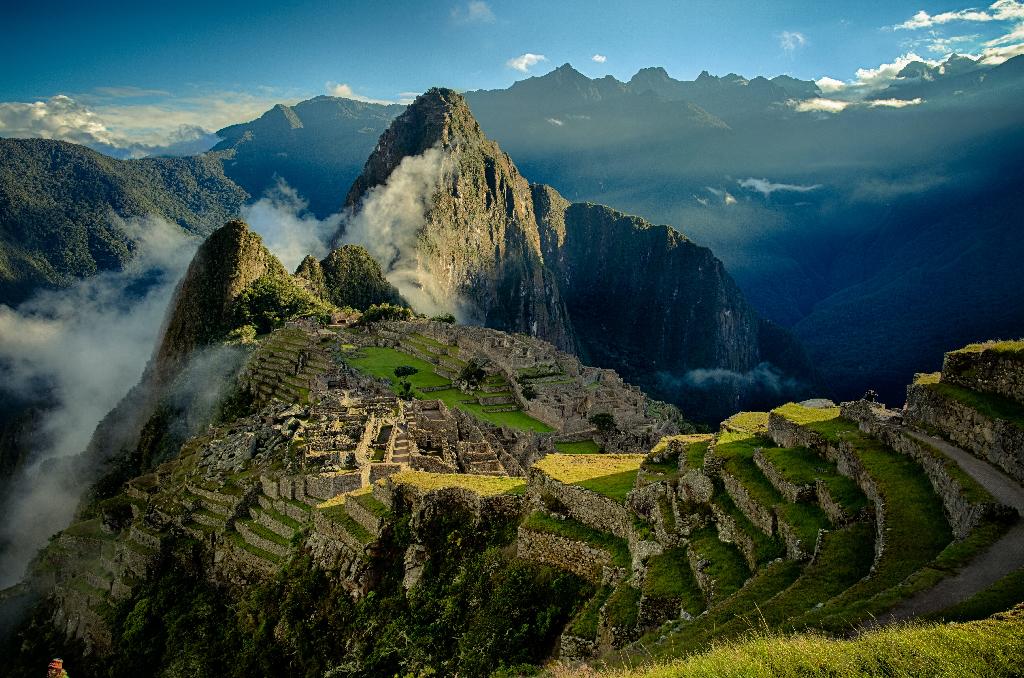
The Inca Trail is a 50km hike from Piscacucho (2400m) to Machu Pcchu (2430m). The journey typically takes up to 4 days and crosses a series of high passes. Dead Woman's Pass is the highest point at 4200m
A rest day or two planning for the next climb had produced a settled determination to climb Huascarán Sur, at 6746m the highest peak in Peru. There were four camps required for the ascent so there was time for gradual acclimatisation.
A cheerful young camp guard, Edgar, was engaged, transport arranged, and, when we reached Musho, arrieros and burros hired to carry our kit up to base camp at 4200m. Unfortunately, we took the walk in too fast and without enough food or water, which left us dizzily setting up the tents when we arrived. Standing up unsteadily after crouching over tent pegs, I saw spots of intense light through a dull red mist before my vision cleared. Sometimes it was better to just have a sit down for a few minutes.
Next day dawned cold and clear. A caracara, a handsome black and white Andean hawk, landed near to our tents, finding the cold air hard work. We took it as a good omen and set off for Camp 1. Perhaps it was: just after gaining the glacier, there was a rumble of broken ice blocks collapsing onto the slabs that we had just crossed below. It was another reminder of the seriousness of the route. A Spaniard with a broken leg had passed us on horseback just below base camp, and a rescue operation with dogs, sled stretchers, and a guy washing blood out of his hair in a meltwater basin was taking place as we moved up to Moraine Camp. On the first night there, we had heard the clattering of a sled being hauled past our tents in the dark and in the morning a neighbour asked if we had seen the dead Spaniard! We also met two English girls who had failed to summit because they were drawn in to the rescue of a couple who had slipped into a deep crevasse. The couple were both dead by the time they were extracted. A New Zealand pair told us about crosses placed on the edge of a crevasse that they could only cross by a narrow snow bridge, à cheval."
In improving weather, we reached Camp 1 at 5300m and intended an early start the following morning, but that was not to be. Although Clive had seemed fine at Moraine Camp, now he was suffering from a cracking headache and becoming increasingly nauseous. We delayed our departure to allow time for improvement but instead his condition deteriorated so he and Pam H had no option but to go down.
Pam C and I set off for Camp 2 but heavy sacks slowed us as we climbed in and out of huge crevasses and between massive seracs hung with icicle columns, bent and folded by the wind.
We carried on hoping to find an easing where we could take a break but with no luck. My calves were tight and painful by the time we reached a levelling on the spur above. From there it seemed a short traverse to the tents of Camp 2, but as we rounded the spur the slope fell away into a hidden snow bowl scattered with fallen ice blocks and threatened by tottering seracs. It was the sort of place to run through but we could barely keep walking and the final pull out of the bowl was a real sting in the tail. The Garganta is the huge saddle between Huascaran Sur and Huascaran Norte and the views were stunning; we felt fully justified in taking a rest day at this camp!
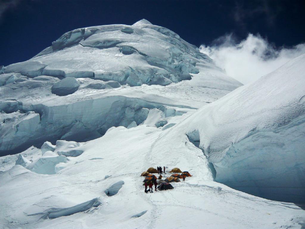
Huascaran Norte (6655m) is the second highest peak in Peru and is most commonly climbed from the saddle "La Garganta" that separates it from Huascaron Sur (6768m)
We turned in early, but at 7 a.m. next morning I unzipped the tent and stumbled out into the windy glare; instead of finding a deserted camp, everyone seemed to be packing up. Some were already heading down. They couldnt all have summited yesterday! I collared a passing Italian and he told me that an English group had been turned back in the night when a snow bridge collapsed leaving an uncrossable 5m crevasse; the route would no longer "go" so everyone was bailing out. Guides from Huaraz would be up to place a ladder across the crevasse in a few days time. All our efforts so far looked like they were wasted. Pam and I hurriedly conferred and decided to stick to our plan to take a rest day then climb next day, at least to get as far as we could. After all we might be able to find a way around the crevasse and it had taken us days to get into this position, so not to be thrown away lightly.
There was no way we were going down on the strength of someone else's failure. When the spindrift cleared there was only ourselves and a couple of Americans left at the camp. We went over to ask them what they planned to do and were told, “we’re gonna sit on our sorry asses all day then go up to take a look at that crevasse tomorrow morning”. They were both named Steve and both from Boston, although one had moved there from Canada so wasn't really American after all. We discussed possible rope manoeuvres to tackle the crevasse, but none of us was very happy about trying to sort out the problem in the dark. Not one of the guided parties had stayed to have a go.
I lay in the tent and dozed, then mid-afternoon took a hard look at Huascarán Norte. There was not the slightest sign of a track. We had no guidebook description but I thought it might be possible to pick out a line from the trail on Huascarán Sur. I walked up to 6000m and gazed intently at the south face. There was a line that looked as though it might "go”. A snow chute in the middle of the face led up to a serac barrier but a ramp seemed to escape up left onto a glacier shelf leading to a levelling on a snow spur. From there it looked like steep snow slopes stretched all the way to the summit. They were cut by a few crevasses, but it looked as though it would be possible to find a way around them. Best of all there was no evidence of falling ice. Arriving back at the camp I was pounced upon by the Steves, who declared their interest in tackling the route when I explained it to them. Pam was quite happy for the four of us to try it more or less together; suddenly we had a new game plan.
The alarm went off at 11 p.m. but it was freezing and the stove took hours to boil water so that we didn't get away until 1 a.m. We plodded over a large crevasse via a bridge of precariously balanced ice blocks and on into the throat of the Garganta taking a wide arc to avoid possible hidden crevasses in the trackless snow. Odd flashes of light betrayed the Americans position ahead of us but we only stumbled onto their tracks when we were well into the snow chute at the base of the face. A steep pull up variable snow, sometimes sinking knee-deep, brought us to the serac barrier where we caught up with the two Steves. They were preparing to pitch the escape ramp up to the left.
The ramp proved easier than expected with careful cramponning and a nearly full moon rendered head torches unnecessary except in the deepest moonshadows amongst the glimmering ice. Emerging onto a glacier terrace, we went on hugging the upper edge under low ice cliffs. This line took us above the rounded snow spur, where I'd anticipated taking a break, and onto steepening snow slopes.
Boston Steve led up direct, but I continued traversing on a line that I'd memorised which should have taken us around the crevasse barring the way. When I got to the point of a safe crossing, however, I stuck my head over the upper edge to find a steep-sided bowl with ice cliffs looming in its upper reaches. I traversed back right, along the lip of the crevasse towards the line Steve had taken, until I reached the point where a vertical crevasse split down from the horizontal one. Pam came up to contemplate the three doubtful options for crossing it.
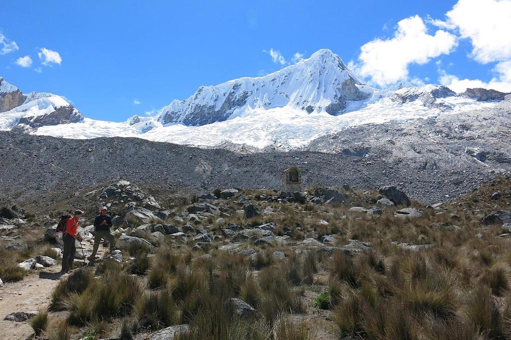
Pisco (5752m) lies approximately 60km north of Huarez. The most poular route crosses the glacier on the left and then follows the skyline to the summit
Suddenly a voice floated up from below: 'Does your route "go" up there?' We were noncommittal and they reported that a meagre snow bridge had halted them. Pam and I finally decided to make a rapid crossing of a cracked ice bridge and it held. Just as we were about to shout down that our route did indeed “go", a whoop from below announced that they had made it across their snow bridge. Now only one crevasse crossing lay ahead and we chopped out the cable of a deeply iced-in "deadman" (anchor) to protect the moves; someone had been that way before! That was reassuring but took nothing away from the adventure of working out our own route through the features of the mountain.
The slopes above steepened and we pitched them with ice axe and snow stake belays but no time for intermediate runners. Boston Steve was keeping a close eye on Canadian Steve who was suffering badly from AMS. He’d never been to this altitude before. We stayed roped in separate pairs. As the edges of the face narrowed, Boston Steve commented, 'We'll soon run out of mountain to climb!' But he needn't have worried: what we had thought was the summit proved to be only the start of a ridge consisting of a succession of false summits that sapped our physical and psychological strength.
One false summit too many and we just slumped down with one accord and rested. When we went on it was with only ski poles and cameras. It was still a head-down slog but suddenly the snow before us fell away and the vast panorama of those glorious northern peaks of the Cordillera Blanca filled our sight: the Huandoy group, Artesonraju, Pyramide, Santa Cruz, Chacraraju, glittered below. I turned to shake hands with Boston Steve and soon Canadian Steve and Pam were joining us with more handshakes and hugs. It was strange to be looking down on Pisco whose summit had felt so high to us just ten days before. We were at 6650m. We took pictures, then the cloud swirled on and it was time to go.
The descent of the ridge was so easy, no longer fighting altitude, that it was embarrassing to think how hard we had found it on the way up. Only Canadian Steve was still in bad shape, complaining of a "black hole in the vision of one eye as his mate shepherded him carefully towards the steeper down-climbing ahead. This was a reversal of the more commonly known tunnel vision sometimes brought on by altitude sickness. It's a sign of incipient HACE but we weren't carrying Dexamethasone so the only treatment was to get him down as fast as possible. Pam and I kept just ahead as a kind of safety net as Boston Steve kept a tight rope on his friend all the way down.
After recrossing the “deadman” crevasse the slope eased and we followed the Americans' tracks to their “meagre snow bridge”; easily jumping the crevasse in descent. Towards the spur we spotted an easier lower line to traverse the glacier shelf but as we approached the ramp a hidden crevasse sucked my leg in to the hip: I threw myself sideways, rolled, and slid out of trouble onto the other side of the break. Pam appreciated the belay but cleared the crevasse easily with a mighty leap, landing on the roll. For the Americans, forewarned was forearmed.
Down the sometimes soft, snow chute with huge strides was very easy going but soft snow in the Garganta built up between crampon points causing balling. We removed our crampons and descended more easily until bare ice lower down threatened to slide mental us off down the ice fall without them.
Back at camp we quickly got a brew on as dehydration was bound to be contributing to Canadian Steve's condition. He arrived looking rough but cheerful just as we ran extact out of fuel. Our dismay soon turned to delight when they passed over a plastic bottle of bencina blanca (white benzene) that they'd found cached in a corner of their tent platform. When the snowmelt had boiled for a few minutes, we all drank thirstily. At such a well-used campsite there isn't going to be any unpolluted snow and bacteria, can live in snow well below freezing so water had to be thoroughly boiled and might need sterilisation tablets as well. Steve's black holes were still with him but there was no way he was going to a lower camp now and a dose of Dexamethasone would help him through the night.
Settled in the tent, Pam and I dozed off to the comforting roar of the stove, waking amid clouds of steam! Next morning Canadian Steve's vision problems had become intermittent although he was very tired: another dose of medication would hopefully sort him out on the way down to base camp. Guides arrived to sort out the snow bridge; ladders were on the way! They were very interested in our ascent. Few attempts were then made on the Huascarán Norte route pioneered by the American schoolmistress Annie Peck in 1908. The previous day, Camp 1 had been crowded and our four figures had become the focus of attention when spotted on the summit slopes.
We were all back in base camp by mid-afternoon but the Americans needed to make the roadhead to stand any chance of catching their plane. Before they rushed off, Boston Steve commented, "Thanks! It's not often things turn out better on account of a problem! Good call!"
Thanks Dave! It goes without saying that "An Expedition Handbook" is essential reading for anyone with an interest in expeditions! Copies can be bought here. For a 20% discount enter the code DWJ20 at the checkout.
Dave will be talking to students of the Diploma in Mountain Medicine (DiMM) in November. For more information about the University of Central Lancashire's DiMM take a look at this.
If you're interested in mountain medicine please take a few minutes to have a look at our archive (500+ posts!) and at the same time, why not join the British Mountain Medicine Society?
Details of the 2023/24 BMMS UCLan Mountain Medicine Winter Webinar Series can be found here. Places are FREE!
Comments
Leave a comment.
Leave a comment.

 )
)